
Mount St. Helens.
Where does one start when talking about it? It's common knowledge that Mount St. Helens is the most recently active volcano in the Cascades, and also the most recently active volcano in the continental USA. Less commonly known is that in historical times, Mount St. Helens has consistently been the most active volcano in the Cascades, erupting at intervals of between 50 and 100 years. It last erupted from 1980 through 1986 or so, with the main eruption being the giant lateral explosion of May 18th 1980 which killed 53 people and did a thorough redecoration job on some two hundred and thirty square miles of landscape. It was months before the worst of the damage was repaired, years before the blasted region started to recover, and some of the effects won't be fully known for decades. In addition, some fortunate coincidences let the blast zone be turned into a testing ground for how both natural and artificially-assisted forests recover from such natural disasters.
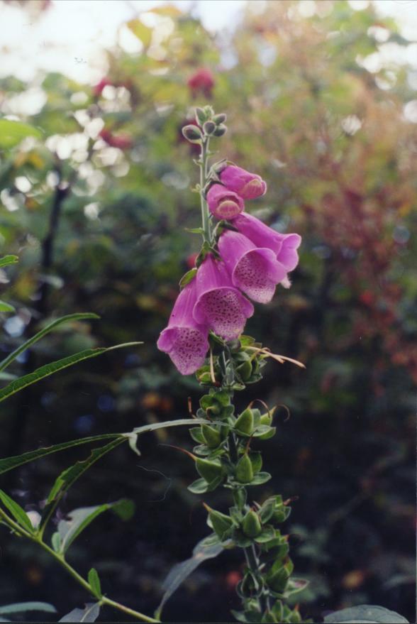
I photographed this tall flower in the wetlands behind the Silver Lake visitor center. After some research, I identified it as foxglove, source of the heart drug digitalis.
If you come from the west as I did, there are two ways to approach the mountain by car, a north route and a south route. I wanted to see the blast area and the crater. These are best seen from the north, so I chose the northern approach route. This approach starts at Castle Rock, WA, and follows Spirit Lake Highway (aka State Route 504) to Johnston Ridge five miles north of the mountain. Johnston Ridge is named for geologist David Johnston, who was on volcano-watch the morning of May 18th and became one of the eruption's first victims.
SR 504 generally follows the course of the Toutle River. The Toutle River Valley was one of the main courses for the mudflows triggered by the May 18th eruption. So, starting about ten miles from Castle Rock, the Toutle River valley is full of mud and ash deposited by the eruption. As you go up the valley, the mud deposits get thicker and the amount of new growth on them gets less and less. Directly below the mountain itself, there's hardly any vegetation at all. Just lots of bland gray mud and ash.
There are five major visitor centers and about a dozen observation points spread along SR 504 between Castle Rock and Johnston Ridge. The first visitor center, at Silver Lake State Park, serves as an introduction to the whole area. It reviews the history of Mount St. Helens and the 1980-86 eruption, including a movie about the eruption and a pretty well-done series of static exhibits about the mountain's history. There's also a nice book-and-video shop, and a nature trail that winds through field, forest, and wetlands. As a nice final touch, a pair of ospreys have a nest in a tree right behind the main visitor center.
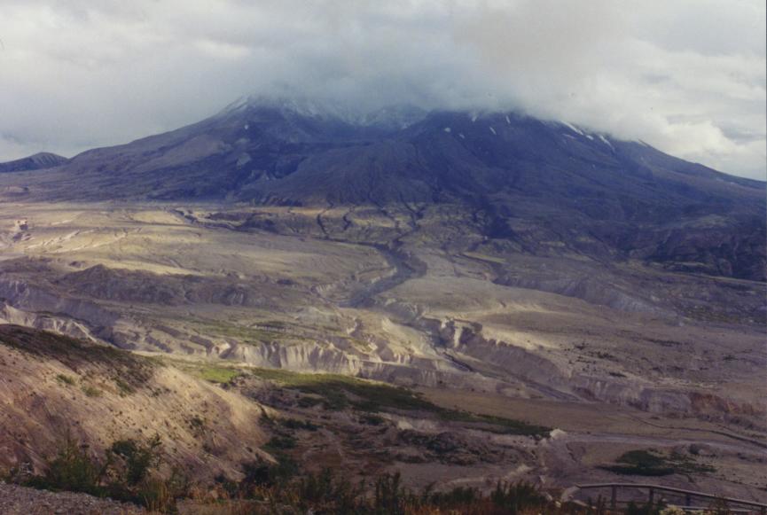
Visitor center #2 is located at Hoffstadt Bluff. It includes a large giftshop and a large concrete platform which overlooks the Toutle River valley. The valley at this point is just starting to show the remnants of the giant mudflow that followed the May 18th eruption. It's impossible to tell what the valley used to look like. All you can see is patches of greenery among large swathes of ugly gray mud and silt.
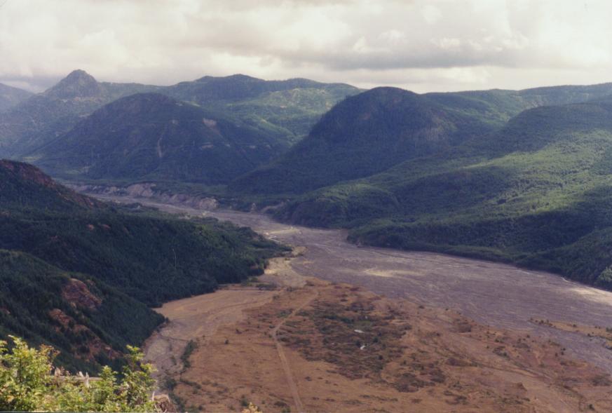
The Toutle River Valley below Hoffstadt Bluff. The tan-gray surface over which the river flows is all mad and ash deposited by the May 1980 eruption. The vegetated area in the foreground is home to a sizable herd of elk.
Just downhill from the visitor center is the base for one of the companies that does helicopter tours of the mountain. I considered taking a tour, but decided against it partly because of the cost and partly because it was a lousy day for a sightseeing flight: fog, mist, occasional rain showers, and a low cloud ceiling.
A few miles short of the third visitor center, the road crosses into the blast zone, the area destroyed by the May 18th, 1980 eruption. The blast zone doesn't have a well-defined edge; it's more that all of a sudden you start seeing lots of white things on the hillsides, which on closer examination turn out to be the whitened stumps of trees snapped off by the blast.
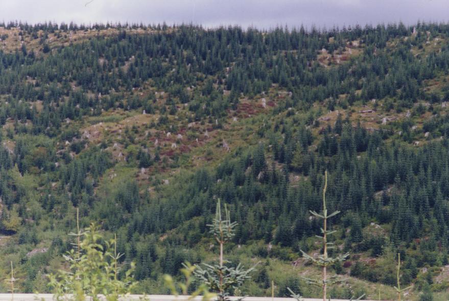
The white specks on this hillside are all stumps killed by the big eruption. All the small trees are less than twenty years old.
Visitor center #3 is where the interesting stuff really started, in my opinion. It's a Forest Learning Center run by Weyerhaeuser Lumber Company in association with the US Forest Service. Weyerhaeuser owns several million acres of forest around Mount St Helens, mostly to the north. It uses this land as a timber plantation, harvesting and replanting trees in regular rotation. The blast of May 18th hit mainly Weyerhaeuser lands. The Forest Learning Center documents Weyerhaeuser's activities in managing its timberland, how it was affected by the eruption, and what it did afterwards. I took it with a grain of salt because after all it is a company project. But even duly salted, it's interesting stuff.
After the eruption, Congress took a lot of Weyerhaeuser's land and turned it into Mt St Helens National Volcano Monument. By a happy coincidence, the monument lands included some but not all of the "blast zone," the region which was stripped bare by the May 18th eruption. This let Weyerhaeuser and the USFS set up a simple experiment. While the monument lands were left to recover naturally, Weyerhaeuser threw a huge amount of resources into clearing, replanting, and artificially accelerating the regrowth of forests on its lands. After 22 years, the contrast between the natural and artificially-enhanced lands is quite striking. The natural lands are recovering very slowly, while the Weyerhaeuser lands have a lush growth of fresh young trees. It's far from being a replacement for the forest that was there before, but it's also a long way ahead of the "natural" area.
Visitor center #4 is on Coldwater Ridge, above Coldwater Lake. Coldwater Lake looks like it's been there forever. In fact, it's been there for exactly 22 years. It was created by the eruption. Coldwater Ridge Visitor Center is the largest and most elaborate of the visitor centers, and offers stunning views of the mountain and the blast zone.
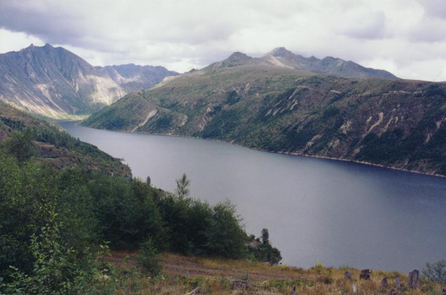
Coldwater Lake. If I didn't know better, I'd think it was a lot older than a mere 22 years. (Afterthought: after this page was first posted, a geologist acquaintance pointed out that you can tell the lake formed recently by the fact that it has no beaches.)
From Coldwater Ridge you can see Mount St. Helens itself quite clearly -- or at least, you can when it's not hidden by clouds, mist, and/or rain.
Visitor center #5 is the Johnston Ridge Observatory. St Helens is almost due south of Johnston Ridge, and the big blast of May 18th blew out the north side of the mountain. So when you're there you're looking almost directly into the giant crater that the blast left behind. Below the mountain is the headwaters of the Toutle River, an ugly, dusty, ashy landscape with large hummocks left by the eruption and a lot of small streams flowing through large channels cut deep into the ash. To the left of the mountain, looking almost due east from the visitor center, you can see several clusters of dead snags in the lee of ridges just east of Johnson Ridge, where the trees were sheltered from the main force of the eruption blast but were seared by the heat of the ash cloud.
Exhibits inside the observatory show how the eruption happened, and how at one stroke the St Helens blast solved several major mysteries for volcanologists. The giant crater left after the blast closely matched several puzzling "half-mountains" known in other locations, such as the San Francisco Peaks in northern Arizona. The hummocks in the avalanche zone matched mysterious formations found in a valley below Mount Shasta.
Seismographs in the observatory show realtime traces from three of the seismometers set up around the volcano. The accompanying text and displays describe how different traces mean different things, with examples from real seismograph segments. The seismometers are so sensitive that a few elk walking around them produce traces on the graph paper. The seismometers also respond to gusts of wind, rockfalls within the crater, and genuine earthquakes below the mountain. Each produces its own distinct trace, and it's not hard to tell them apart.
Outside is a large concrete observation area on the south side of the ridge, so you get a panoramic overview of the entire valley and the mountain above it. As with Grand Canyon and Crater Lake, photographs don't do Mount St Helens justice. I didn't really understand at gut level what the May 1980 eruption did until I saw it laid out in front of me in graphic detail. Three-foot-diameter trees snapped off like twigs; other trees left standing but with all the leaves and bark seared away; ash deposits a foot or more thick; a landscape in the middle of a rainforest that looks like it was transplanted from a desert; and above it all, the looming emptiness of the crater with bits of mountain around it.
Mount St. Helens and the streams which unite to form the Toutle River, seen from Johnston Ridge observation deck.
By late afternoon, the mist had dropped so low that it was hiding most of the mountain. All the visitor centers close at 6PM, and it was a long way back to my hotel, so I left Johnston Ridge at about ten to six and headed back. On the drive back, the sun broke through the clouds long enough to throw a rainbow onto the mist above the Toutle River. It was a perfect "last memory" for my trip, although I'd have preferred it not end at all.
But it did. So, the next morning I had to head home. Even though there's still stuff I'd like to see in the Cascades. Hopefully, someday I'll be able to go back.
Update 2004: At the end of September 2004, Mount St Helens stirred again, for the first time in eighteen years. Earthquake swarms were followed by ash and steam eruptions, with a high possibility of more serious eruptions. Minor eruptions have continued off and on ever since, with occasional ash spurts and a slow, steady extrusion of a new lava dome. For the latest information on the mountain's activity, see the United States Geological Survey's Cascades Range Current News Update. You can also look at what the mountain is doing right now through the live Mount St Helens VolcanoCam located at Johnston Ridge Visitor Center.
Further Reading and Links
Mount St Helens is a very popular topic for both books and webpages. Almost every book written about volcanoes since 1980 has devoted a chunk of its pages to Mount St Helens, because the 1980-86 eruptions were the most thoroughly documented and examined volcanic eruptions in history.
Books:
FIRE MOUNTAINS OF THE WEST: THE CASCADE AND MONO LAKE VOLCANOES
Harris, Stephen L.
c.1988, Mountain Press
ISBN: 0-87842-220-X
A combination of long-lived tectonic activity and large cities mean that the West Coast of North America hosts some of the most potentially dangerous volcanoes in the world. The Cascades range includes Mount St. Helens, Mt. Rainier, Mt. Hood, Mt. Shasta, and several other well known volcanoes. Several of them are considered active or potentially active right now, and pose major risks to humans. Mono Lake is a region in southern California that is also considered at high risk for major volcanic activity.
MOUNT ST. HELENS: THE ERUPTION & RECOVERY OF A VOLCANO
Carson, Rob
c.2000, Sasquatch Books
ISBN: 1-57061-248-X
This is a detailed account of St. Helens's 1980-86 eruption cycle, and of the ways the devastated region recovered after the enormous lateral-blast eruption of May 18th, 1980. It's very interesting to compare this book, written with twenty years of observations behind it, to VOLCANO: THE ERUPTION OF MT. ST. HELENS (see below), and see what the earlier book got right and wrong. A great many predictions about how the area would or wouldn't recover turned out quite wrong.
NORTHWEST EXPOSURES: A Geologic Story of the Northwest
David Alt & Donald Hyndman
c.1995, Mountain Press
ISBN: 0-87842-323-0
ROAD GUIDE TO MOUNT ST. HELENS
Decker, Robert and Barbara
c.2002, Double Decker Press
ISBN: 1-888898-06-2
A self-contained guidebook to some of the sights visible from the roads within Mount St Helens Volcano National Monument.
VOLCANO COWBOYS: The Rocky Evolution of a Dangerous Science
Thompson, Dick
c.2000, St. Martin's Press
ISBN: 0-312-20881-2
Volcanology is one of the most dangerous fields of science, because it involves close-up and personal encounters with active volcanoes and volcanic phenomena. As a result, it tends to attract a unique sort of person, equal parts scientist and adventurer. This book is a look at the "cowboys" who have built volcanology into a valid branch of the earth sciences. Much of the book is devoted to how the volcanologists dealt with the 1980 eruption of Mount St Helens, what they got right about it and also what they got wrong.
VOLCANO: THE ERUPTION OF MOUNT ST. HELENS
Various
c.1980, Longview Publishers
ISBN: 0-914842-54-4
A look at the eruption of Mount Saint Helens, written shortly after the May 1980 explosion. It's interesting to look back on this book with twenty years of hindsight, and see what it got right and wrong.
Websites:
Mount St Helens is not a national park. Instead, it and the surrounding land belong to Gifford-Pinchot National Forest, which puts it under the jurisdiction of the US Forest Service. The USFS maintains a large and very good site about the volcano and the eruption that made it infamous.
Of course the United States Geological Survey watches Mount St Helens very closely, and maintains a page-full of information and links to USGS pages about the mountain. Another interesting USGS-run site is the Crater Lake Data Clearinghouse.
A vacationer's guide to Mount St Helens and the surrounding area can be found on GoNorthwest.com, a web-based travel guide.