
The Legend of Crater Lake
The Klamath Amerinds tell of a time long ago when Llao, Lord of the Below-World, lived below the great mountain Lao-Yaina (Mount Mazama). Skell was the spirit of the Above-World. Llao often came up and stood on top of Lao-Yaina, and his head would touch the stars near the home of Skell. There was no lake then, just a hole through which Llao passed to see the outside world. One day, Llao saw Loha, daughter of the Klamath Indian chief, and fell in love with her beauty. She rejected him because he was ugly and was from the Below-World. He got angry and swore that he would take revenge on her people. He tried to destroy the people with the curse of fire. The Klamath Indian chief sought help from Skell.
Skell descended from the sky to the top of Mount Shasta. Skell and Llao were thundering and trembling the Earth, hurling red hot rocks back and forth to each other (from Mount Shasta to Mount Mazama), causing great landslides. A terrible darkness spread over the area for days. All spirits of Earth and sky took part in this battle, creating intense fear among the people. Attempting to calm the ferocious volcano gods and to make up for the sins of the tribe, two medicine men offered to sacrifice themselves and jumped into the pit of Below-World. Impressed by their heroic sacrifice, Skell fought even harder. He finally defeated Llao, driving Llao deep down into the Below-World. He collapsed the top of Mount Mazama to imprison Llao forever beneath the world. Skell wanted peace and tranquility to cover up this dark pit, so he filled it with the beautiful blue water.
-- from "History of Crater Lake"
Mount Mazama is probably the most famous nonexistent mountain in the world. Once it was a huge Cascades stratovolcano, estimated between 11,000 and 12,000 feet high. It destroyed itself in a cataclysmic series of eruptions about 7700 years ago, which produced several cubic miles of ash and debris, and resulted in the formation of a classic volcanic-collapse caldera about five by six miles in size and almost four thousand feet deep. Over time the caldera's floor was sealed by fresh lava flows and it slowly filled with water, creating Crater Lake.
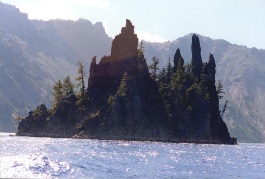
Today, Crater Lake fills the interior of the old caldera. It's pure, clean fresh water, all from rain and snow runoff, with a clarity unmatched by any other lake in the USA. The lake's deepest point is almost two thousand feet below the surface, making it the deepest lake in the USA and one of the deepest freshwater lakes in the world. Two islands break the lake's surface. One is the large cinder cone called Wizard Island, which formed after Mazama collapsed and probably after the crater had already filled partly with water. The second island is the Phantom Ship, a remnant of an ancient lava dike which is almost invisible in some lighting conditions and looks from some angles like a windjammer under sail. Two other cones formed after Mazama's collapse and the lake's formation, but neither ever broke the surface.
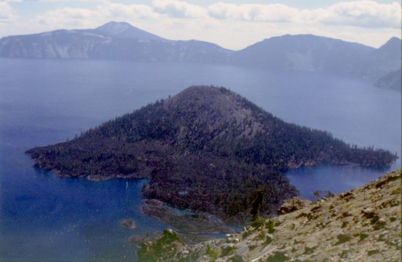
Wizard Island, in Crater Lake. This was taken from an overlook on the west side of the crater rim.
Crater Lake is a strange place because of the way it tricks the eyes. The normal sense of perspective is just not there. I think it has something to do with being able to see the entire crater in a single look around, just turning your head left to right. It may also have something to do with the clear air. Whatever the reason, the result is that there's nothing to give the view any scale. The far side of the crater looks no more than a mile away. In reality, it's more than five times that far. The crater is a rough oval over five miles across at its widest point, and a little more than four at its narrowest. You don't get any sense of the crater's real scale until you see one of the tour boats on the lake, and realize that tiny, tiny white speck is a forty-foot-long motorboat and the first thirty or forty feet of its foaming white wake.
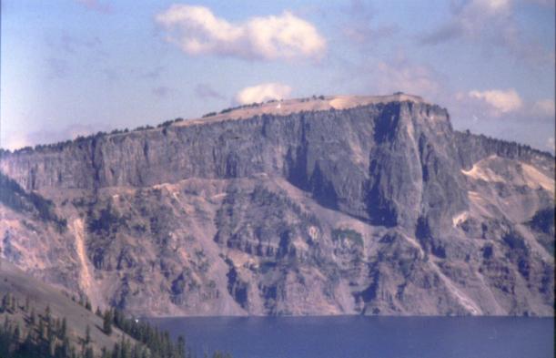
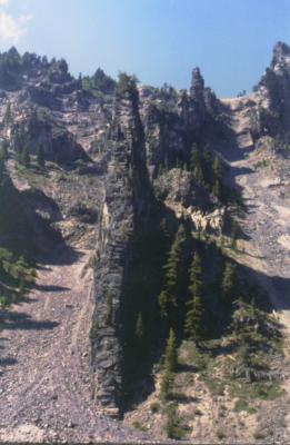
The huge lava flow called Llao Rock, and the older rock strata below it. Was this where Llao stood during his battle with Skell?
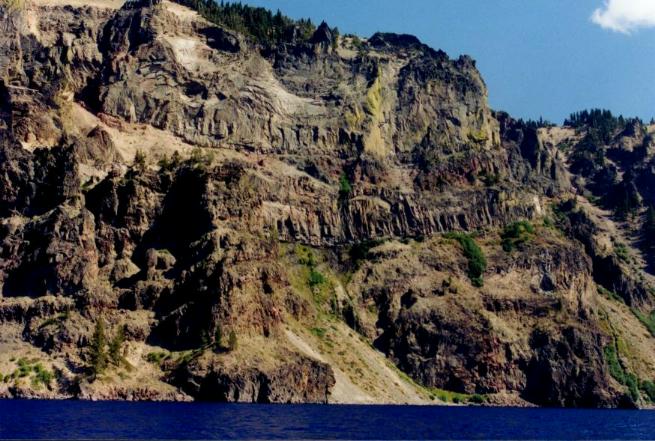
The caldera walls expose a marvelous cross-section of old Mazama's interior. Of course all the rocks are igneous. They include intrusive dikes, extrusive lava flows, pumice and ash deposits. Numerous multi-layer lava flows show clearly why volcanoes like Mazama are called stratovolcanoes. Mazama was clearly built up layer by layer from dozens of lava flows, dikes, ash and pumice eruptions, and other volcanic activity.
I drove the Rim Drive all the way around, stopping at many of the overlooks and taking lots of pictures of different rock formations. Geologists have done an impressive job of piecing together the history of Mazama's history and particularly its last great eruption. During that eruption, huge pumice-falls covered large tracts of ground just north and west of Mazama. Thick layers of pumice don't make for fertile soil, so it's not surprising that these "pumice deserts" have little if any vegetation even today, over 7700 years later.
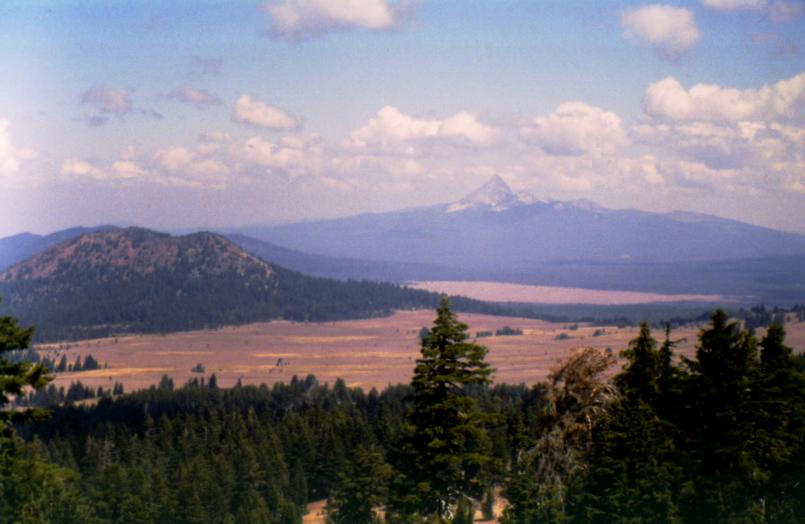
Mount Thielsen is the tall conical peak in the distance. The large meadow below is one of the Mazama pumice deserts.
The Rim Drive doesn't only show off Crater Lake. Several overlooks look the other way, giving panoramic views of many other Southern Cascades volcanoes. I took some pictures of these. Unfortunately, many of them didn't come out because of the haze in the air, but I got one or two usable ones. For example, this one of Mount Thielsen, a heavily ice-scarred "Matterhorn" type peak thirty miles northwest of Crater Lake.
These "Matterhorn" peaks or pyramidal peaks are common in the central Cascades. They occur wherever a tall stratovolcano was heavily glaciated during the last Ice Age, and has not been volcanically active since then. What seems to happen is that the ice sheets carve away all the flanking lava flows and deposits of ash and pyroclastic debris, and leaves only the heavier, stronger rock surrounding the volcano's throat. Thus you get the tall, narrow "needle" of rock with sharp drops on all sides.
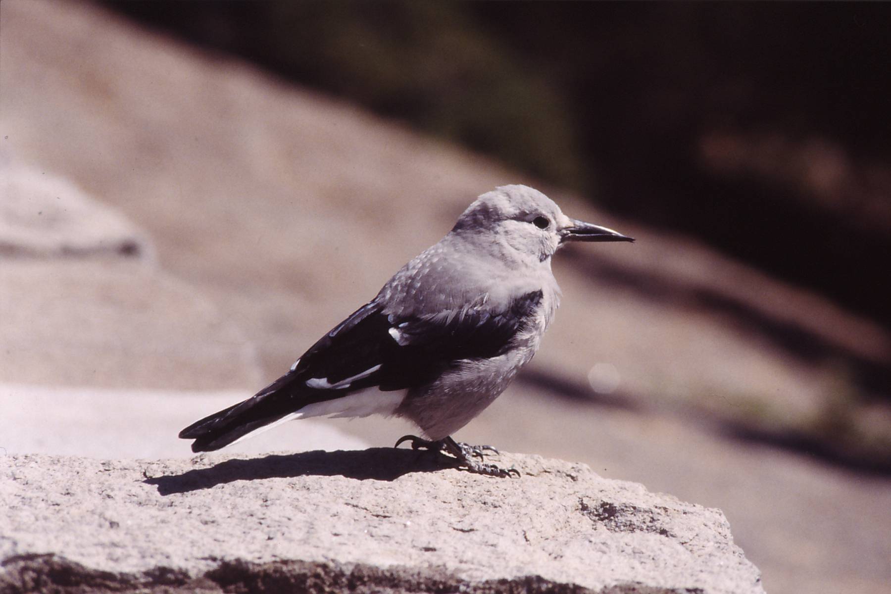
A Clark's Nutcracker at an overlook on the West Rim Drive
As at Lassen Peak, animals and birds around the Crater Lake village and overlooks have gotten quite tame, because of tourists who make a habit of feeding them. This bird, called a Clark's Nutcracker, was so fearless that it hopped around on a low stone wall only a few feet away, long enough for me to get a couple of pictures.
The capstone of the day was the Crater Lake Volcano Cruise.
The Volcano Cruise is unique. For a cost of $20 per person, you get a 1 and 3/4ths hour cruise around the lake aboard an excursion boat with a ranger-naturalist giving an informative talk, describing many of the major features of the caldera and the old volcano. The ride is interesting and lots of fun. However, there's a catch. The boats, naturally, are on the lake. The Rim Drive, naturally, is on the Rim. The only way to get from the one to the other is a trail that descends the 550 or so feet from Rim to lakeshore. So you walk down to the boat dock. Then afterwards, you walk back up. Oh, and remember that all this is going on at between 6200 and 7000 feet altitude. This did not match my definition of "fun."
The cruise itself did, though. The Volcano Cruise starts from Cleekwater Cove on the lake's north shore. It circles the lake counter-clockwise, going past Llao Rock and the Devil's Backbone and giving you a closeup view of both of them. From there, the boat heads over to Wizard Island. Wizard Island is a large, almost perfectly shaped cinder cone located near the west side of the caldera. Its exact age is unknown, but it certainly formed after Mazama collapsed, and probably after the lake began to fill the crater. On the other hand, the oldest trees on the island are estimated at 800 years old, so the island itself must be at least that old. Probably much older, since the island started as volcanic ash and cinders, and had to build up enough soil for trees to root in.
The lava dike called the Devil's Backbone, exposed on the caldera's slope. This shot was taken from the lake tour boat.
In any case, Wizard Island rises about 1600 feet from the lake bottom to the surface, then another 760 feet above the surface. The cruise boat docks here for a few minutes, then continues the tour. It's possible to climb to the cone's crater, but it requires getting off the boat and waiting for the next boat to come by. An interesting side note is that the boathouses on Wizard Island are where the tour boats usually spend the winter season. The tall island provides a nice sheltered lee from the winter storms.
After leaving Wizard Island, the boat cruises along the north shore, looking at other volcanic rock formations. The way that Mazama collapsed left a wonderful cross-section of its lower cone exposed on the caldera walls, so you can see in detail all the structures that make up a large stratovolcano. There are sills, dikes, lava flows, and pumice masses. At a couple of points the boat passes close to small waterfalls formed by springs in the rock which drain into the caldera, and help keep Crater Lake full. At other places, low points on the shore contain permanent snowbanks. These parts of the caldera never get enough sun to melt all the snow, so some of it remains all year round.
Next, the boat passes by the Phantom Ship. This island is a remnant of an ancient vertical dike. It's the oldest rock exposed in the entire lake, so old that it pre-dates the formation of Mazama, not just the collapse. From some angles it resembles a windjammer under full sail. The "Phantom" part of its name comes from the fact that in misty weather conditions and from far away (say, the far caldera rim), the island seems to disappear against the background.
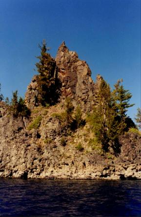
A view of the northern side of Phantom Ship, with the sun almost behind it.
A section of the southern side of Phantom Ship, lit by the late afternoon sun.
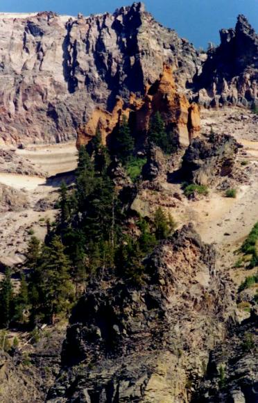
"Pumice Castle," an unusual formation about halfway up the crater wall.
After Phantom Ship, the boat moves over toward the crater wall again, and passes by several more fascinating rock formations. "Pumice Castle" is a narrow vertical chimney of tough reddish rock, which has been slightly slower to erode than the rock around it. As a result, it's become a tower set well out from the crater wall. And the erosion patterns of wind and water have shaped it into something that does look a lot like a castle perched on the crater wall.
Beyond Pumice Castle, the boat passes another area where the erosion of the crater wall has exposed a nice cross-section of the old volcano, and the many lava flows and other eruptions that built it. Mazama was an ancient volcano, and had built and rebuilt its cone several times before it finally blew up. There are many, many different deposits of volcanic rock exposed along the crater wall: sills, dikes like Devil's Backbone, chimneys like Pumice Castle, big lava flows like Llao Rock, ash and pumice deposits, fossilized mineral springs, and more.
More lava flows and other volcanic rocks, exposed in the crater wall.
Finally, the boat heads back to Cleekwater Cove, and you get to make that long climb back to the Rim.
Crater Lake hosts a sparse but functioning ecosystem. One bizarre aspect of that ecosystem is the presence of thermophilic bacterial mats, similar to the bacterial mats found around deep-marine "hot smoker" springs. A question immediately leaps to mind: How did they get there? The deep-ocean bacteria travel from one vent complex to the next via water currents. But how did they, or any similar bacteria, get into a land-locked lake with no ocean access, which didn't even exist a mere seven thousand years ago?
Next step: an all-day drive from Klamath Falls to Castle Rock, WA, near Mount St. Helens.
Further Reading and Links
Crater Lake is a very common topic in geology and volcanology books, because it's such a perfect example of a volcanic caldera. So I have many books that talk about it to some extent:
Books:
ROAD GUIDE TO CRATER LAKE NATIONAL PARK
Decker, Robert & Barbara
c.1997, Double Decker Press
ISBN: 0-9621019-8-2
A small booklet that guides you through a tour of the sights visible from the Rim Road around Crater Lake. Easy to follow, easy to understand, and accurate without being too technical. I recommend it highly.
ROADSIDE GEOLOGY OF OREGON
David Alt & Donald Hyndman
c.2000, Mountain Press
ISBN: 0-87842-409-1
This entry in the Roadside Geology series discusses and describes geology as seen from the roads of Oregon. Of course it has a long section about Crater Lake and the surrounding area.
VOLCANOES IN AMERICA'S NATIONAL PARKS
Decker, Robert & Barbara
c.2001, W. W. Norton
ISBN: 962-217-677-1
This is a guide to the volcanoes found in America's national parks. It includes a section on Crater Lake.
GEOLOGY OF NATIONAL PARKS
Harris, Tuttle, Tuttle
c.1997, Kendall/Hunt
ISBN: 0-7872-1065-X
A textbook on the geology of several major US national parks. Original text written by Ann Harris, updated by Esther Tuttle and Sherwood Tuttle. Chapter 34 focuses on Crater Lake National Park.
Websites:
As with all national parks, the National Park Service has a set of pages about Crater Lake National Park in general. It also has several pages devoted specifically to the Park's geology.
The US National Parks Net is a private organization dedicated to providing thorough and complete information about all US national parks. It includes a page about Crater Lake National Park.
The United States Geological Survey maintains a page-full of information and links to USGS pages about Crater Lake. Another interesting USGS-run site is the Crater Lake Data Clearinghouse.
ESRI, the makers of the ArcGIS software, have posted a two-page article from their newsletter ARCUser about a thorough underwater survey of Crater Lake.