
This was mainly a travel day, from Klamath Falls up to Castle Rock, WA, a town near Mount St. Helens. I started out along the same route that I took to Crater Lake the day before, and was able to use Roadside Geology of Oregon to identify a volcano along the route. Mount McLaughlin is a large volcano just west of Klamath Falls and south of Crater Lake. It shows a classic shield-volcano profile: wide and low. The authors of the book also made the very sensible observation that it's not hard to tell if a volcano in this area has been recently active. Any peak that is heavily glacier-scarred is probably extinct, because it hasn't repaired the damage done in the last Ice Age 15,000 years ago. But any peak that shows only a few or no glacial effects is probably still active. Such as Mount McLaughlin, which from the east looks like a perfect shallow cone with no major glacial scarring at all. On the west side there's a lot of glacial scarring, but even so, McLaughlin looks a lot more like a dormant volcano than a dead one.
It was a long and tiring drive, but I managed a couple of stops anyway. The main one was at Lava Butte, which is part of Newberry Crater National Monument. Newberry Crater is the caldera of a large shield volcano. I didn't know this, but the Cascades Range includes a number of shield volcanoes. They just don't get noticed much because of all the higher and more impressive stratovolcanoes and cinder cones. Lava Butte is a cinder cone that appears to be associated with Newberry, but is much younger than Newberry. As cinder cones go it's pretty ordinary, about 1200 feet high with a well-defined crater, made of loose pyroclastics, with a couple of lava flows that came from its base. One large flow of aa lava that came from Lava Butte is still almost barren hundreds of years later, while the cone's crater itself has trees growing in it.
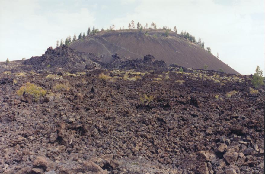
Lava Butte from ground level, and a part of its main lava flow
Other volcanic features in the area include a "lava cast forest," which I wanted to visit but didn't have time. A lava cast forest is something that forms when a flow of very hot lava engulfs a forest of adult trees. The lava coats the tree-trunks to a certain depth, then hardens in place. The trees are killed by the heat but not burned. Eventually the trees rot away, leaving only the lava, which is full of holes where the trees used to be.
I stayed on US 97 north to Bend, Oregon, then took US 20 across the Santiam Pass to I-5. Awesome country every inch of the way. Never a minute when there weren't multiple mountains in view. On top of that, it was very rural, back-country kind of land, with lots of farms, widely scattered small towns, and lots of greenery.
Going across US 20, I got looks at several other major Cascades peaks: the Three Sisters, Mount Jefferson, Mount Bachelor, Black Butte, and one called Three-Fingered Jack. Black Butte is a tall cinder cone; the others are all old stratovolcanoes. Jefferson and Three-Fingered Jack are sharp, steep "Horn" style peaks like Mt. Thielsen further south. The "Horn" type peak develops when a dead volcano becomes heavily glaciated, as all of these mountains were in the last Ice Age. The glaciers carve away all the softer rock and ash from the volcano's upper slopes, leaving only the harder rock that formed the volcano's central neck.
On the other hand, the Three Sisters are a cluster of three stratovolcanoes which look precisely like I always imagined Cascades volcanoes would look: cloud-draped conical peaks with snowpack and glaciers visible on all sides.
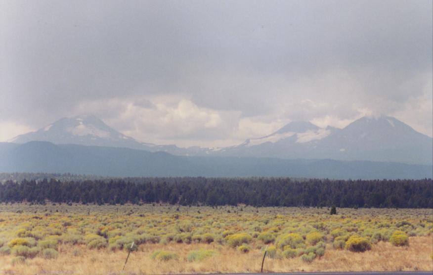
The trio of stratovolcanoes called the Three Sisters, seen from a scenic viewpoint on US 20 west of the town of Sisters. Left to right are South, Middle, and North Sister.
Around the year 2000, satellite data indicated that the ground southwest of the Sisters was bulging upward. This could indicate magma moving far below the surface, and possible future volcanic eruptions. So the USGS has increased their assigned risk rating, and both it and its associate the Pacific Northwest Seismograph Network started watching the Three Sisters a lot more closely. In recent years the activity has stopped, but the USGS continues to list the Three Sisters as having Very High threat potential.
Next day's agenda: Mount St. Helens.
Further Reading and Links
Unfortunately, the mountains of the Central Cascades don't seem to attract a lot of attention in the popular press, so I have no books that are specifically about them, and few that even mention them.
Books:
ROADSIDE GEOLOGY OF OREGON
David Alt & Donald Hyndman
c.2000, Mountain Press
ISBN: 0-87842-409-1
This entry in the Roadside Geology series discusses and describes geology as seen from the roads of Oregon. It has several sections about the volcanoes of central Oregon.
Websites:
The United States Geological Survey maintains a page-full of information and links to USGS pages about the Three Sisters. Their Cascades Range Summary page includes short descriptions of the Three Sisters, Newberry Caldera, and many of the other volcanoes in this area.