
This day started in Red Bluff, CA, and ended in Klamath Falls, Oregon, with several stops along the way. I didn't follow my original planned route, but Lady Luck was feeling generous, so this way of getting from point A to point B worked out far better than the original plan probably would have.
The first stroke of luck was that I had some time to kill in the morning, so I visited a "fish ladder" in Red Bluff. The Red Bluff Diversion Dam diverts a part of the Sacramento River's flow into a huge irrigation canal. The fish ladder is a way for migrating salmon to get past the diversion dam. It's operated by the California Fish & Game Department. Part of the fish ladder is an elaborate fish trap, which lets Fish & Game workers safely catch fish within the ladder long enough to sex and measure them. This lets them keep track of how many fish are running upstream. On this day the fall run of Chinook salmon was underway, and I was able to watch while the Fish & Game Dept. man on duty caught, measured, and released a number of salmon on their way upriver to spawn.
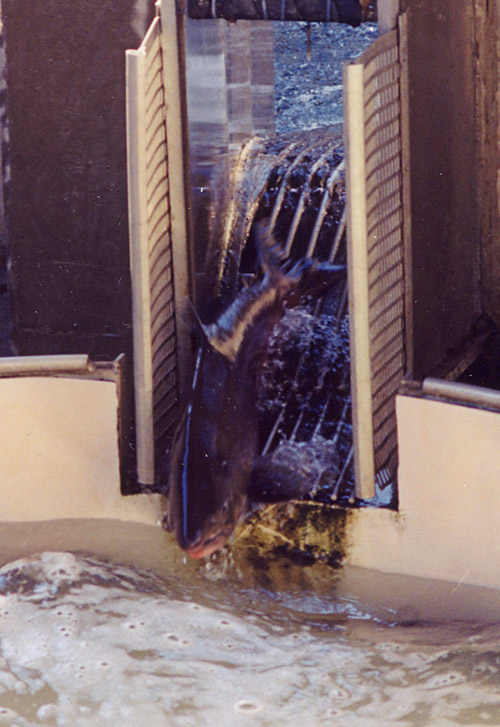
A Chinook salmon enters the fish-trap catch basin in the Red Bluff fishing ladder
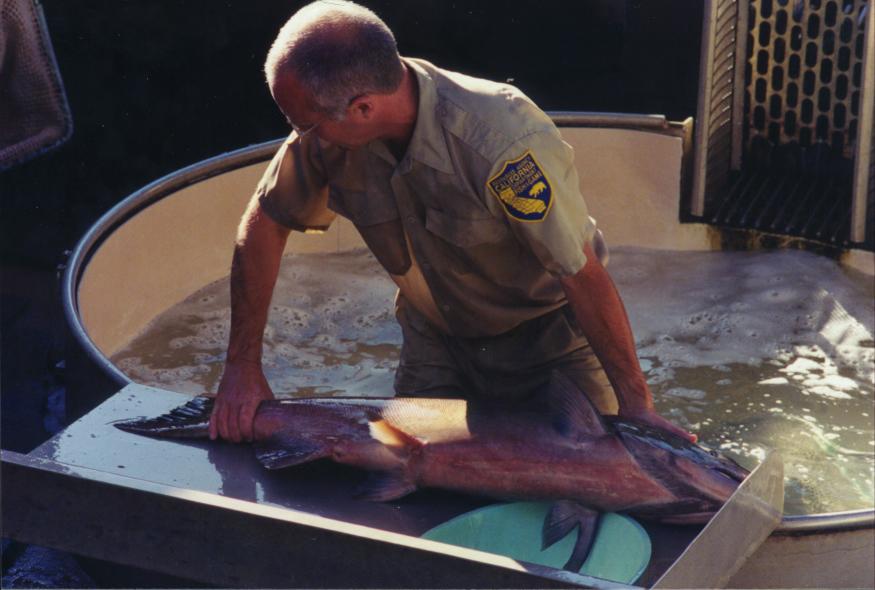
The giant salmon on the measuring block
I was there for about fifteen or twenty minutes, and watched him catch and measure about a dozen fish. The last one he caught was a male which he said was the biggest he'd seen that year. He couldn't measure it accurately -- it was longer than the fish-trap's 40-inch-long measuring scale. He guessed it at 43 inches long and over 50 lbs. (I'd include this gentleman's name except I forgot to write it down.)
I'll never wonder again why so many sport fishermen consider salmon a worthy quarry.
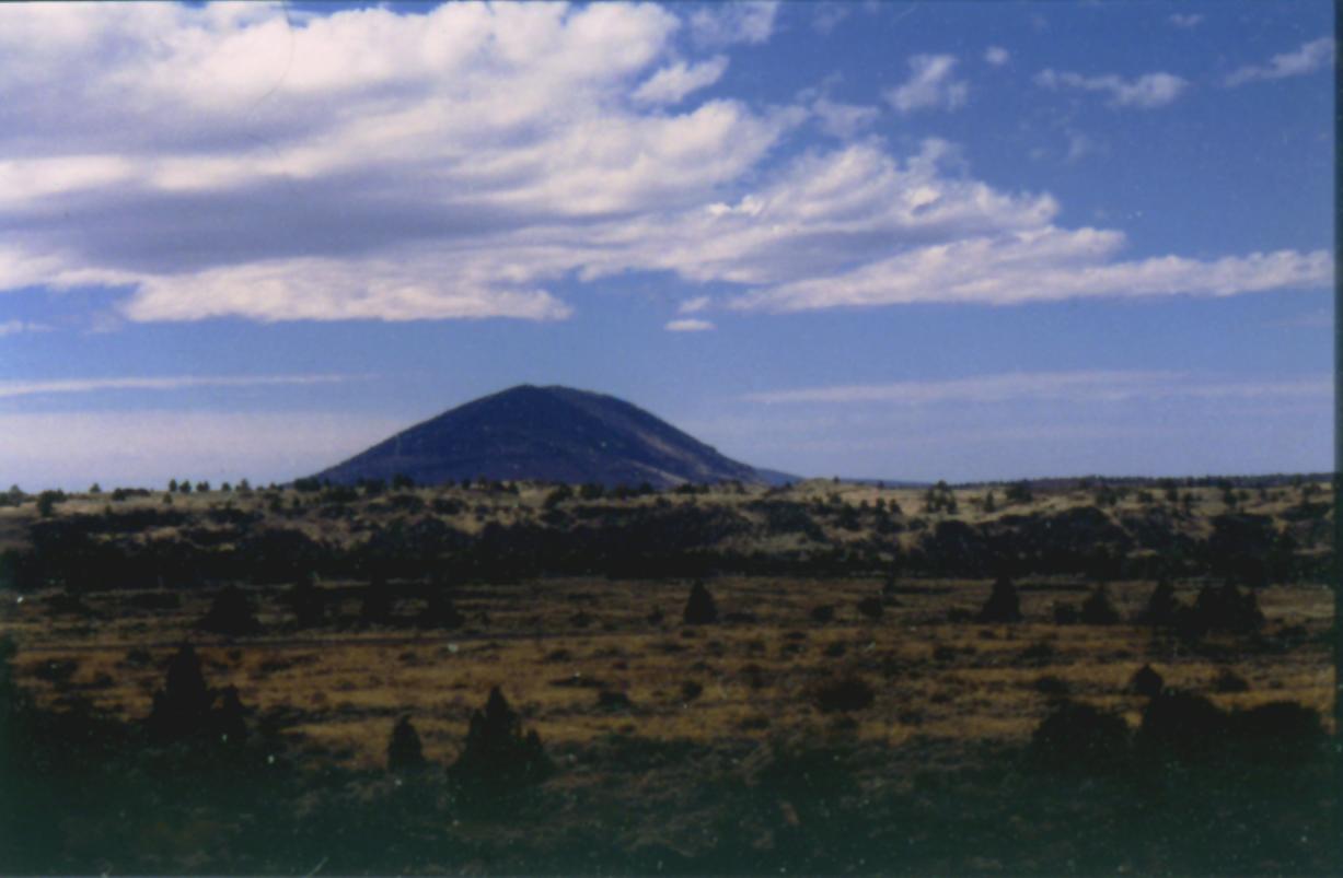
The second stroke of luck occurred on Interstate 5: clear weather and a "scenic overlook" pull-off which gave a stunning view of Mount Shasta from about 20 miles away. Like most of the Cascades peaks, Shasta is a stratovolcano. In fact, it's really a composite of several different volcanoes, which erupted at different times over the past few thousand years and all eventually grew together into one big mass. At 14,162 feet, Shasta is the tallest peak in the southern Cascades and one of the tallest in North America. It has several glaciers and a permanent snowcap, so it looks awesomely beautiful in sunlight. The weather conditions on this day were slightly unusual, and for most of the day Shasta had a "hat:" a huge disc-shaped cloud bank which started at about 12,000 feet and obscured the summit. Several stops at different spots produced several good pictures of it.
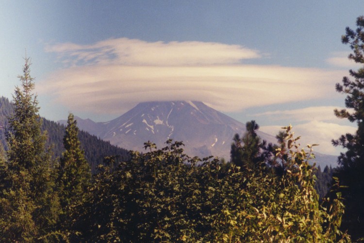
Mount Shasta with cloud hat, seen from an overlook on I-5 about 15 or 20 miles to the south
When I got home and researched this cloud formation, I found that it's called an orographic cloud bank. Shasta is well-known for this kind of thing. The mountain stands so high above the surrounding terrain that it breeds its own weather. A Web search led me to an entire page devoted to the clouds that appear over and around Mount Shasta.
I stopped in the city of Mount Shasta for lunch and some fresh camera film, then went on, up US Route 97. A little while later I found a really nice scenic overlook on US 97, pulled off and took several pictures of Shasta's north side, and the landscape around it.
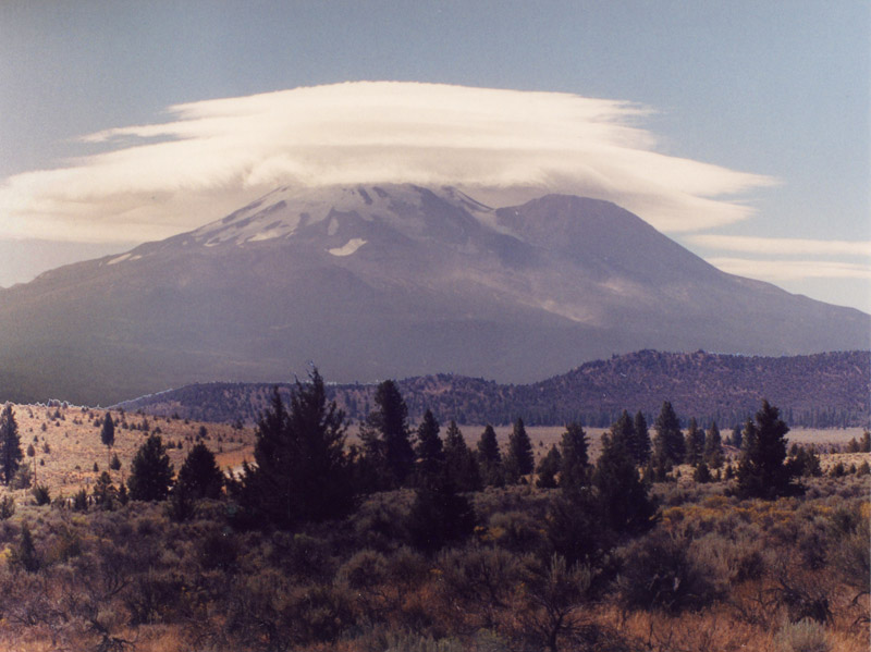
Mount Shasta's northern side, seen from an overlook on US 97 about 10 or 12 miles north or slightly northeast of the mountain. The huge bulge on the right (northwest) flank of the mountain is Shastina, a secondary cone and a sizable volcano in its own right.
After passing Shasta, my route took me along the south side of Lower Klamath Wildlife Refuge. Here, a couple of stops got a few nice bird sightings: a Northern Harrier, a couple of ducks that I couldn't identify, and lots of American Coots. Rather annoying, that: I was hoping for lots of new birds, but most of what I did see was coots, which I can see at home any time.
Next, it was south to Lava Beds National Monument, a large area covered by cinder cones, buttes, sills, dikes, intrusive and extrusive lava flows and other igneous features. Most of the igneous rocks here are basaltic rhyolite, which fractures easily and forms huge heaps of talus on the lower slopes of the ridges. One series of fissures spawned a large lava flow known as the "Devil's Homestead." At the place where the road crosses it, the Devil's Homestead flow is composed mainly of heavy, dark-colored, sharp-edged chunks, the kind that geologists call aa lava. It's also mostly black, almost barren of plants, and generally one of the ugliest landscapes I think I've ever seen.
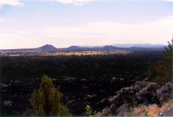
The "Devil's Homestead" lava flow. The hills in the background are all cinder cones.
Not far from Devil's Homestead is a small, old cinder cone called simply Black Crater. There's a short trail that leads to the crater, which gives a nice overlook of the immediate region. Close around Black Crater can be found samples of both aa lava and the smoother, more "flowy" looking type of lava called pahoehoe.
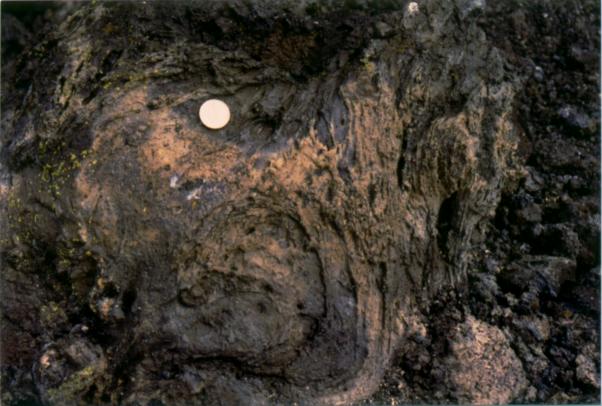
A swirl of hardened lava near the small cinder cone called Black Crater. The coin is an ordinary quarter included for scale.
The view from Black Crater's summit is a lot like the view of Devil's Homestead: ugly. I'm used to views of field and forest. Lava Beds is mostly bare rock with only scattered patches of plant life. It's hard to imagine how anything could live here, animal or human.
The Lava Beds landscape seen from the summit of Black Crater, with another cinder cone in the distance and lava flows all around.
Besides these above-ground formations, Lava Beds Monument also includes a large number of lava tubes, relics of past lava flows. A lava tube forms when the top surface of a lava flow, the part exposed to air, cools and crusts over, while the hotter lava keeps flowing inside. After the lava flows out and away, what's left behind is a hollow tube. The current ground level is even with the tops of the old tubes, so the tunnels are underground caves. A few have collapsed ceilings, making them accessible from ground level. The Visitor Center was built near one of the smaller lava tube caves, called "The Mushpot." The Mushpot has been improved so that anyone could explore it: a metal stairway for easy access, a smoothed footpath along one side, electric lights, and display signs that highlight some of the cave features. There's even a small sort of theater area with benches, where a ranger-naturalist can give talks about the lava cave.
I've been in regular limestone caves a few times, and I was surprised at how the Mushpot was both similar to and different from them. Like virtually all caves, the Mushpot is isothermal -- that is, it's all the same temperature inside, and much cooler than the outside air. There are hardly any mineral formations. Those that do exist are small and dull compared to the magnificent stalactites, stalagmites, flowstone, flower-crystals, and other formations found in limestone caves.
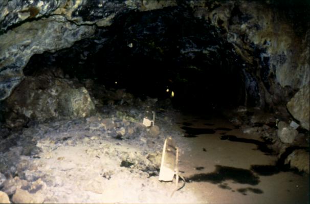
Looking down the Mushpot lava tunnel
I tried one or two natural-light pictures inside The Mushpot, but they didn't come out very well.
There are many other lava-tube caves at Lava Beds. Some go so deep and get so cold that they have permanent ice formations in them. I took a look around in two of these other lava-tube caves, Skull Cave and Valentine Cave, but decided not to explore very deep into them. Both are "undeveloped" caves. That means they're still in more or less their natural condition. The floors and ceilings are uneven, and there are no structures or aids except for handrails in steep spots and metal staircases that let you descend to lower levels. There are no lights except for any flashlights you carry in. And I was alone. Caving alone with only one light source, even in well-known and well-explored caves, isn't a smart thing to do.
Lava Beds Monument also includes "Captain Jack's Stronghold." Captain Jack was a Modoc Amerind chieftain who led a band of rebel warriors for a couple of years. They used the Lava Beds region as their base. The US Army's campaign against them didn't last very long compared to some, but it was phenomenally expensive and rapidly acquired a reputation as the worst duty post the Army had to offer. It's not hard to understand why: from one end of Lava Beds to the other, there's nowhere that has more than a couple of inches of soil over very hard igneous bedrock. There's nowhere to build buildings, so the soldiers lived in tents, for months on end. There's little food or water and not a whole lot of rain, so almost all supplies have to be brought in. Captain Jack and his band eventually surrendered after the Army found their stronghold and managed to cut them off from their only source of fresh water: Tule Lake.
After leaving Lava Beds Monument I headed north toward Klamath Falls, with a stop on Tule Lake National Wildlife Refuge. There I saw several more new birds: Western Grebe, White Pelican, Redhead duck. There were many other birds there too, but they were too far away to identify. I also noticed that Mount Shasta dominates the skyline even from almost fifty miles away.
Next stop: Crater Lake National Park.
Further Reading and Links
For more information on Mount Shasta and Lava Beds National Monument, try any of these:
Books:
ROADSIDE GEOLOGY OF NORTHERN AND CENTRAL CALIFORNIA
David Alt & Donald Hyndman
c.2000, Mountain Press
ISBN: 0-87842-409-1
California is such a large and geologically rich state that it gets two volumes in the Roadside Geology series. This one is about the northern half of the state. It includes a section on Shasta-Trinity National Forest.
ROADSIDE GEOLOGY OF OREGON
David Alt & Donald Hyndman
c.2000, Mountain Press
ISBN: 0-87842-409-1
This entry in the Roadside Geology series discusses and describes geology as seen from the roads of Oregon. It includes a section on Lava Beds National Monument.
Websites:
Since Mount Shasta and the surrounding area are not a national park, the National Park Service doesn't have a webpage about them. However, the US Forest Service maintains pages about Shasta-Trinity National Forest and Shasta Wilderness Area.
The United States Geological Survey maintains webpages about both Mount Shasta and Lava Beds National Monument.
The California Geotour includes several links to articles about both Shasta and Lava Beds.